North Barkly Project – Rare Earths
The Company has recently commenced applying for Exploration Licences (ELs) is its own right in the search for REE and base metals. To date, five contiguous EL Applications covering an area of approximately 3,270km2 have successfully been lodged (ASX Announcements 2 February 2022 and 26 May 2022).
1.Large scale Rare Earths and Base Metal project identified
An initial review of recent geochemical and geophysical work by Geoscience Australia led to the identification of a new rare earths and base metals project area on the northern Barkly Tableland and the Company three Exploration Licences to cover the prospective areas.
Rare Earths
- Very large drainages with peak rare earths and niobium assay values in sediments.
- Long weathering history and lack of outcrops are favourable for near surface enrichments.
- High sediment assay values of the more valuable rare earths including Neodymium.
Base Metals
- An historic 88m intersection of copper lead zinc mineralised black shale in BHP core hole MD1.
- Very large drainage in an area of cover with peak values of copper cobalt bismuth molybdenum tellurium niobium palladium uranium vanadium tungsten.
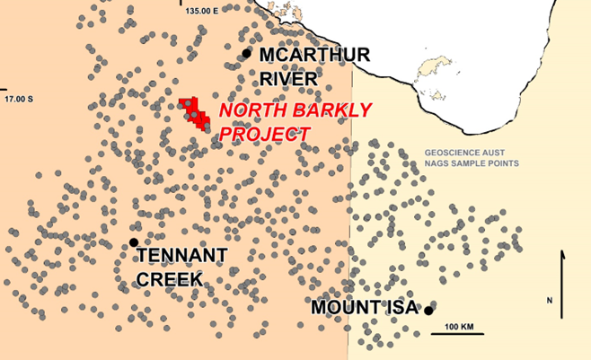
Fig.1 Location of the Project and Geoscience Australia Sampling
The North Barkly Project
The project is comprised of three Exploration Licence applications (33128 / 29 / 30) totalling 1,950 sq km over pastoral lands on the Barkly tablelands 500km northwest of Mount Isa and 150km southwest of McArthur River.
Some of the applications will need Native Title agreements prior to being granted so timing is unknown.
The Barkly region has been subject to intensified geophysical, geochemical and geological investigation by Geoscience Australia over recent years, leading to the recognition of potential for repetitions of the large mineral deposits such as those mined at McArthur River and in the Mount Isa area.
These two largest deposits in this region are hosted by pyritic black dolomitic shale horizons, usually adjacent to large faults, and in the lowest part of the shale unit where it abuts a fault, or in the keel of a local structure.
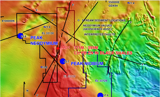
Fig.2 Project EL Applications with fine fraction Neodymium (ppm) results on magnetics. The coincident peak in Niobium supports the rare earths prospectivity
The North Australian Geochemical Survey (NAGS) results are publicly available from Geoscience Australia. CML has examined the large volume of data and has identified this area as having the strongest indicators of a major rare earths deposit. The peak rare earths trend northwest to southeast through the project area and are strongly supported by the peak niobium scandium tellurium palladium and cobalt values in the centre.
These elements are indicative of a carbonatite source, which may be one or more of the magnetic bodies close to the peak niobium.
BHP (CR 19930191) drilled a core hole MD1 to 415m at a site 10 km north of the peak sample, close to strongest magnetic bodies, and noted post Mesozoic brecciation in sediments from 37.4m to 44.6m, and further down, weak copper lead and zinc disseminations, stringers, and veinlets in contorted zones between 311m and 399m. No rare earths analyses were conducted.
The project area is characterised by a lack of outcrop, and strong weathering, features which are conducive to rare earths enrichments in the near surface.
A base metal potential also exists within the project. The tuffaceous black dolomitic pyritic shale intersected by BHP in MD1A, is the preferred host rock for the major base metal deposits in this region.
The base metal sulphides indicate that a mineralising process has occurred locally, and viable grades may be found in a more favourable site nearby. The Geoscience Australia geophysical data (Fig.3) demonstrates that this prospective conductive horizon underlies the entire project area, generally at about 350m depth.
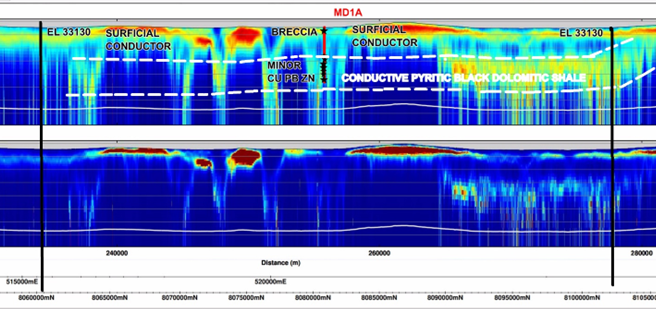
Fig.3 Geoscience Australia Tempest Airborne EM Section 117002 N-S through hole MD1A.
2. RARE EARTHS PROJECT EXPANDED
An ongoing study by CML management and its consultants of the very large public analytical database released by the Geoscience Australia (GA) from its North Australian Geochemical Survey which covered the entire Barkly region west of Mount Isa with very widely spaced stream sediment samples of various sieve sizes, and with a variety of analyses for all elements, has revealed a continuous 160-kilometre trend of peak rare earth anomalism with accompanying high values in supporting elements, notably niobium chrome and uranium.
The Company expanded its Barkly North Rare Earths Project (ASX announcement 2 February 2022) by applying for two adjoining Exploration Licences (ASX announcement 26 May 2022) to the northwest to secure a 160-kilometre linear extent of the rare earths trend revealed by the Geoscience Australia conducted North Australian Geochemical Survey (Figure 1).
Proposed Exploration Programme
After the ELs are granted, CML proposes to define the sources of the stream sediment metals and rare earths by conducting more detailed sampling. The current and any future Geoscience Australia data will also be examined in more detail, in particular the geophysics. The BHP MD1 drill core will be located and, if possible, be analysed for more elements, including rare earths.
Drilling will take place, after the targets are well defined.
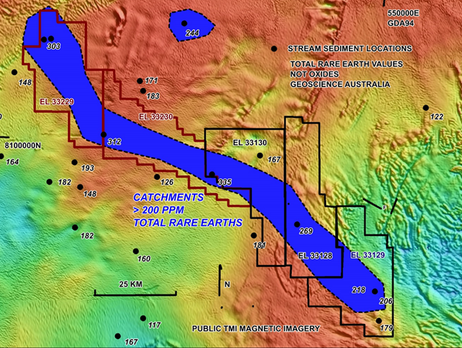
Figure 1. New EL Applications 33229 and 33230 over the NW Extensions to the Rare Earths Trend
The project area is covered by lateritised sediments with strongly developed clayey soil profiles, and the trend bears no relationship to the underlying basement rocks, or to magnetic features.
The Company management and consultants believes that this extraordinary trend in stream sediment REE anomalism is caused by a previously unrecognised ionic clay hosted rare earths mineralisation. Ionic clay rare earths deposits have advantages over hard rock rare earth deposits. They are cheaper to mine and process, and the waste material does not present problems with toxic elements. Much of the world supply is from clay hosted deposits.
Base Metal Potential
In addition to the prospects for ionic rare earths, the Barkly North project area has had a long-recognised potential for major base metals deposits in the underlying unexposed older sequences. These sequences include those that host the major shale hosted and IOCG deposits in McArthur River and Mount Isa districts.
The 1993 BHP corehole MD1 in the centre of the project intercepted a 100m thick black dolomitic shale with scattered copper lead and zinc sulphides (ASX Announcement 2 February 2022). A lack of data to guide exploration hampered efforts to select drill sites as follow up holes. This problem is being overcome by Geoscience Australia which has selected the area for detailed study and has recently been publishing their seismic and detailed gravity surveys.
The recent detailed gravity data is proving very useful and has revealed a nonmagnetic gravity trend arcing through MD1. This has provided CML with a target for future follow up geophysics and possible drilling.
Nonmagnetic gravity ridges such as this are most likely to represent the dense prospective pyritic dolomitic shale which hosts the mineralisation intercepted in the BHP drillhole.
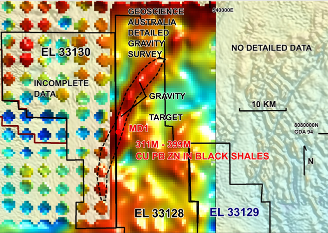
Figure 3. Detailed Gravity (GA)) outlining the denser sediments trending through BHP 1993 hole MD1
Further west, within the new EL applications (33229 and 33230), the GA detailed gravity survey outlined other gravity targets, some of which are magnetic. The adjacent or combined magnetic and gravity responses are typical of IOCG styles of mineralisation. They could alternatively represent intrusive bodies, with mineralisation on the contacts with carbonate sediments.
The depths of these western targets are unknown, but they can be calculated by modelling the new detailed data.
GA has verified the existence of IOCG style alteration and mineralisation in the Barkly region They have drilled combined gravity and magnetic targets through similar cover, about 250 km to the south of the project, and have triggered an exploration rush in that area.
Offer of EL 33130
Previous CML EL application 33130 has been offered for grant, and it is estimated that EL 33128 and 33129 will also be offered over the next few months. The newer applications ELs 33229 and 33230 are expected to be granted before January 2023.
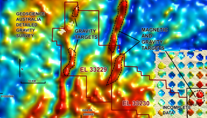
Figure 4. Gravity and Combined Gravity – Magnetic Targets outlined by the GA Detailed Survey in the Western Part of the CML Project area.
CML Programme
CML proposes to firstly conduct more surface sampling throughout the project area once granted to better define and identify the sources of the rare earths. It is anticipated that a programme of shallow drilling traverses will then allow the confirmation of a mineral resource.
The gravity and magnetic targets will be modelled. Those that are confirmed as being caused by rocks at reasonable depths may be further investigated with more geophysics and drilling.